🌊 NASA Develops New Ocean Floor Map Using SWOT Satellite Data
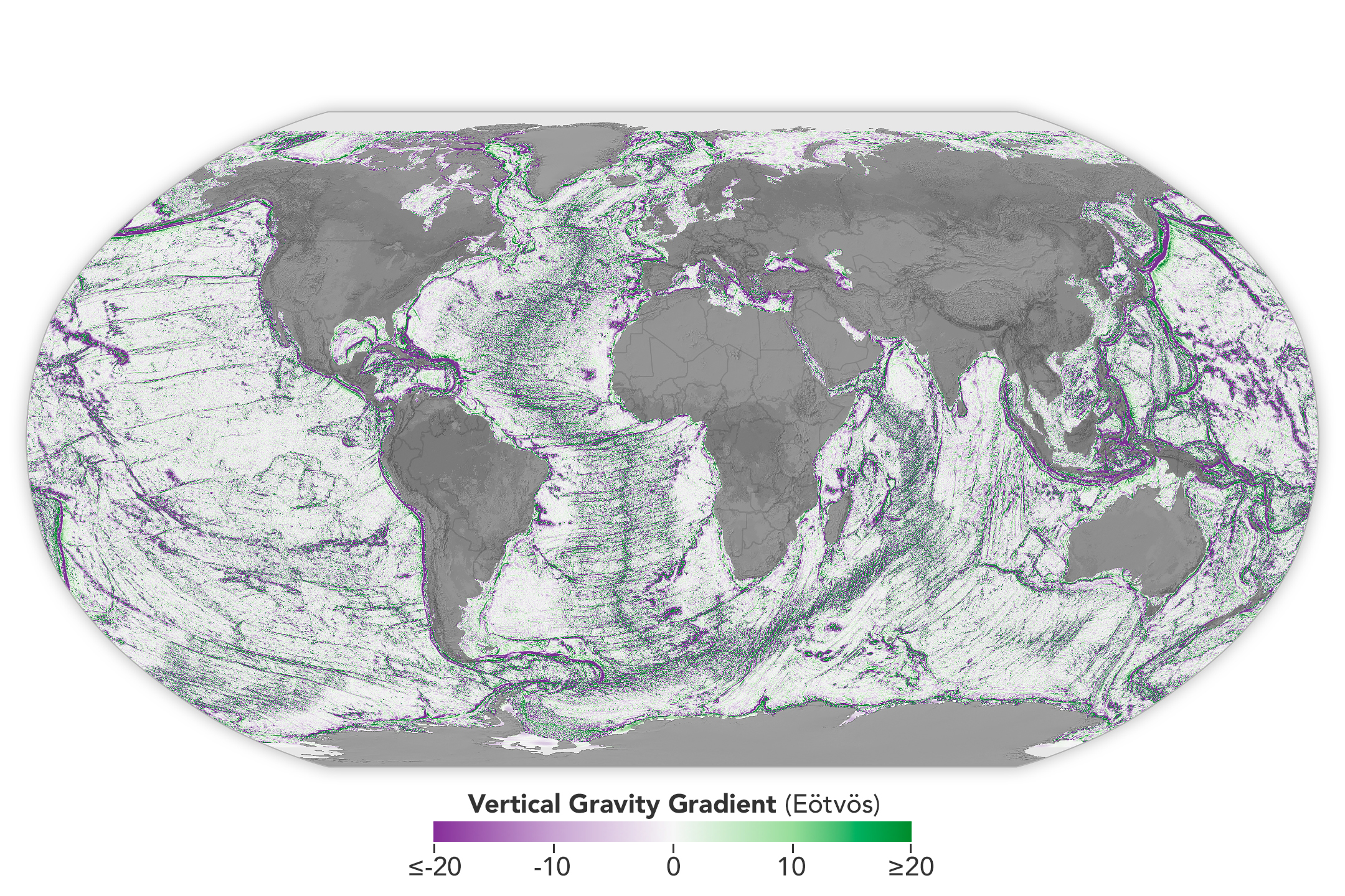
Recently, NASA has created a new, highly detailed map of the ocean floor using satellite data from the SWOT Satellite. This advancement will significantly improve our understanding of ocean dynamics and underwater features.


4
🚀 About SWOT Satellite
The Surface Water and Ocean Topography (SWOT) satellite was launched in 2022 as a joint mission between NASA and CNES.
The main objective of this mission is to collect precise data on how Earth’s water bodies—such as oceans, rivers, and lakes—change over time.
⚙️ Key Features of SWOT Satellite
SWOT uses an advanced instrument known as the Ka-band Radar Interferometer (KaRIn). This technology enables the satellite to measure the height, width, and elevation of surface water bodies with high accuracy.
The satellite works by bouncing microwaves off the surface of water and calculating the return time, allowing scientists to track dynamic water movement in real time. It provides high spatial resolution data, making it far more detailed than previous missions.
SWOT has the capability to monitor over 55% of large-scale global floods during their entire lifecycle due to its frequent Earth orbits. It circles the Earth and scans nearly 90% of the planet every 21 days.
🌍 Functions and Capabilities
The SWOT satellite can observe almost all rivers wider than 330 feet and more than one million lakes and reservoirs larger than 5 acres. This makes it a powerful tool for global water monitoring.
It is also capable of detecting very small differences in ocean surface elevation, especially around currents and eddies. These areas play a crucial role in absorbing heat and carbon from the atmosphere, which is important for understanding climate change.
🌱 Significance
The new ocean floor mapping using SWOT data will help scientists better understand ocean circulation, climate patterns, flood forecasting, and water resource management. It also contributes to improved disaster preparedness and environmental monitoring.
🌊 SWOT सैटेलाइट से NASA ने समुद्र तल का नया नक्शा तैयार किया
हाल ही में NASA ने SWOT Satellite के डेटा का उपयोग करके समुद्र तल का एक नया और अत्यधिक विस्तृत नक्शा तैयार किया है। यह विकास महासागरों की संरचना और गतिशीलता को समझने में महत्वपूर्ण भूमिका निभाएगा।
🚀 SWOT सैटेलाइट के बारे में
Surface Water and Ocean Topography (SWOT) सैटेलाइट को 2022 में NASA और CNES के संयुक्त मिशन के रूप में लॉन्च किया गया था।
इसका मुख्य उद्देश्य पृथ्वी के जल निकायों—जैसे महासागर, नदियाँ और झीलें—में समय के साथ होने वाले परिवर्तनों का सटीक मापन करना है।
⚙️ SWOT सैटेलाइट की प्रमुख विशेषताएँ
SWOT में Ka-band Radar Interferometer (KaRIn) नामक उन्नत उपकरण लगाया गया है, जो जल निकायों की ऊँचाई, चौड़ाई और सतह की ऊँचाई (elevation) को मापता है।
यह सैटेलाइट माइक्रोवेव तरंगों को पानी की सतह से टकराकर उनके वापस आने के समय को मापता है, जिससे जल की गतिशीलता (dynamic movement) को ट्रैक किया जा सकता है। यह उच्च स्थानिक विभेदन (high spatial resolution) प्रदान करता है।
यह सैटेलाइट पृथ्वी का लगभग 90% भाग हर 21 दिनों में स्कैन कर सकता है और बड़े पैमाने की 55% से अधिक बाढ़ को उनके पूरे जीवनचक्र में मॉनिटर कर सकता है।
🌍 कार्य और क्षमताएँ
यह सैटेलाइट 330 फीट से अधिक चौड़ी लगभग सभी नदियों और 5 एकड़ से बड़े 10 लाख से अधिक झीलों और जलाशयों का अवलोकन कर सकता है।
इसके अलावा, यह महासागरों में छोटे-छोटे प्रवाह (currents) और भंवर (eddies) के आसपास सतह की ऊँचाई में सूक्ष्म अंतर को माप सकता है, जहाँ महासागर द्वारा ऊष्मा और कार्बन का अवशोषण होता है।
🌱 महत्व
SWOT सैटेलाइट द्वारा तैयार किया गया यह नया समुद्र तल नक्शा महासागरीय धाराओं, जलवायु परिवर्तन, बाढ़ पूर्वानुमान और जल संसाधन प्रबंधन को बेहतर समझने में मदद करेगा। यह आपदा प्रबंधन और पर्यावरण संरक्षण के लिए भी अत्यंत महत्वपूर्ण है।