
Published: 29 October 2026 | Vitorr Classes Editorial
A research-based explainer on Cyclone Arnab, NASA satellite observations, the Bay of Bengal and the science of extreme weather.
Key facts: NASA reports that Arnab formed on 25 October, was observed by NOAA-20 on 26 October, and made landfall on 28 October along the Andhra Pradesh–Yanam coast. The sustained wind estimates cited by NASA were about 140 km/h during the satellite observation and 130 km/h at landfall.
A Storm That Arrived Late in the Season
The Bay of Bengal is no stranger to tropical cyclones, but Cyclone Arnab arrived after an unusually quiet start to the 2026 North Indian Ocean named-storm season. NASA Earth Observatory reported on 29 October that Arnab formed on 25 October and moved toward India's eastern coast. Its late appearance raises a useful question: why do some seasons begin quietly and then produce destructive storms? The answer involves ocean heat, atmospheric circulation, vertical wind shear, and short-term weather conditions. A late first named storm is noteworthy, but one event alone cannot establish a long-term climate trend.
What NASA Observed From Space
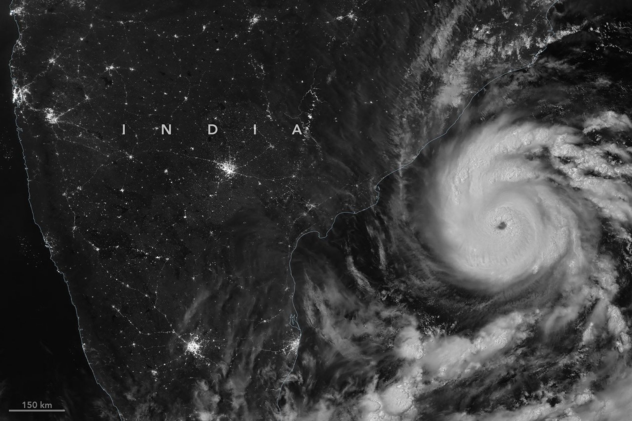
NASA's Earth Observatory highlighted a nighttime image captured by the VIIRS instrument aboard the NOAA-20 satellite at 20:12 UTC on 26 October, equivalent to 1:42 a.m. Indian Standard Time on 27 October. The satellite recorded the storm's cloud structure while lights from populated areas remained visible on the dark land surface. Satellite images help meteorologists identify a cyclone's organization, position, movement and surrounding cloud bands. However, a single satellite image cannot reveal every hazard at ground level; forecasters combine multiple observations and models.
How Strong Was Cyclone Arnab?
According to the India Meteorological Department figures cited by NASA, sustained winds were approximately 140 kilometres per hour around the time of the satellite observation. When the cyclone crossed the Andhra Pradesh and Yanam coast early on 28 October, sustained winds were approximately 130 kilometres per hour. These figures refer to sustained winds, not necessarily the strongest individual gusts. Differences in measurement periods and reporting conventions can complicate comparisons between cyclone agencies. Wind is only one component of cyclone danger: flooding, storm surge, damaged infrastructure and disrupted livelihoods can be equally consequential.
How a Tropical Cyclone Forms
Tropical cyclones draw energy from warm ocean water. Moist air rises over the sea, cools and condenses into clouds, releasing latent heat that can reinforce the circulation. As pressure falls near the centre, more air flows inward. Earth's rotation helps organize that flow, while favourable upper-level winds allow the storm to remain vertically aligned. Warm water alone is not sufficient: strong vertical wind shear can displace thunderstorms away from the circulation and weaken development. This is why ocean temperatures cannot by themselves predict when or where a cyclone will form.
Why the Bay of Bengal Is Vulnerable
The Bay of Bengal combines warm tropical waters with densely populated coastlines and large river deltas. Low-lying coastal settlements, ports, fisheries and agricultural areas may be exposed to several hazards simultaneously. Storm surge can push seawater inland, heavy rain can overwhelm drainage systems, and strong winds can damage buildings and power networks. The extent of damage depends on the cyclone's track, local geography, preparedness, construction quality and the timing of evacuation. Vulnerability is therefore both a physical and a social issue.
What Happened on the Andhra Pradesh Coast?
NASA reported that Arnab made landfall along the Andhra Pradesh and Yanam coast early on 28 October. Contemporary reporting cited by NASA described evacuations, damaged homes and farmland, and deaths associated with the cyclone. Early casualty and damage figures may change as local authorities assess affected communities. For a public-information article, the responsible approach is to avoid treating preliminary counts as final. Readers should consult official state disaster-management bulletins and the India Meteorological Department for location-specific updates and instructions.
Can El Niño Change Cyclone Activity?
El Niño is a recurring warming of parts of the central and eastern tropical Pacific Ocean that can influence atmospheric circulation far beyond the Pacific. NASA noted research suggesting that El Niño conditions can be associated with fewer and less intense tropical cyclones in the Bay of Bengal in some analyses. This is a statistical relationship, not a rule that prevents an individual severe storm. The precise outcome in any season depends on several interacting conditions. Researchers also distinguish seasonal associations from the attribution of one particular storm to a climate pattern.
Does Climate Change Cause Every Cyclone?
Climate change can influence the environment in which cyclones develop, including ocean temperatures, atmospheric moisture and coastal sea level. But attributing a specific cyclone to human-caused warming requires dedicated scientific analysis. It would be misleading to claim that one storm proves climate change or that a single season disproves it. A stronger discussion separates observed events, long-term trends, physical mechanisms and uncertainty. Rising sea levels can increase the baseline risk of coastal inundation even where changes in cyclone frequency remain uncertain.
The Hidden Economic Costs
Cyclone damage is not limited to the buildings destroyed during landfall. Fishing trips may be cancelled, agricultural fields can become waterlogged or saline, schools may close, and businesses can lose electricity and transport access. Households may face costs for temporary shelter, repairs and lost wages. Public authorities must allocate resources to emergency response and rebuilding. These indirect effects can continue long after winds subside, particularly for communities with limited savings or insurance. Resilient infrastructure and reliable early warnings can reduce the human and economic toll.
How India Tracks Cyclones
The India Meteorological Department monitors tropical systems using satellites, radar, surface observations, ocean data and numerical weather-prediction models. Forecasts typically describe a cyclone's likely track, intensity and associated hazards, with uncertainty that increases farther into the future. A forecast cone is not the boundary of all possible dangerous weather. Heavy rain and strong winds can extend outside the expected centre track. Residents should follow official district-specific warnings rather than interpreting one colourful map in isolation.
What Families Should Do Before a Cyclone
People living in exposed areas should identify the nearest official shelter, keep essential documents protected from water, maintain emergency lighting and drinking-water supplies, and follow local evacuation orders. Avoid walking or driving through floodwater because depth, current and hidden hazards can be difficult to judge. Stay away from damaged electrical equipment and downed power lines. During a cyclone, verified updates from government authorities are more reliable than viral social-media claims. Preparedness should be tailored to local conditions and official guidance.
Why This Matters Beyond India
Tropical cyclones affect coastlines across the world under different regional names, including hurricanes and typhoons. The same core scientific principles govern their formation, but local risks vary with coastline shape, settlement patterns and disaster preparedness. Arnab offers a case study in the value of open satellite imagery, coordinated forecasting and early public communication. The broader lesson is not that every cyclone can be prevented, but that better information and resilient communities can reduce avoidable harm.
The Bigger Lesson
The story of Cyclone Arnab connects satellite technology, ocean science, public administration and everyday human security. A scientifically informed society needs more than dramatic images: it needs clear explanations of what is known, what remains uncertain, and which decisions reduce risk. For students and general readers alike, the cyclone demonstrates why environmental science and disaster management are central to understanding contemporary India and the wider world.
Frequently Asked Questions
When did Cyclone Arnab form?
NASA reports that the cyclone emerged over the Bay of Bengal on 25 October 2026.
When did Arnab make landfall?
It crossed the Andhra Pradesh and Yanam coast early on 28 October 2026.
Which satellite photographed Arnab?
The VIIRS instrument aboard NOAA-20 captured the nighttime image highlighted by NASA.
Does El Niño stop cyclones from forming?
No. El Niño can influence seasonal probabilities, but individual cyclones can still occur.
Where should readers find emergency updates?
Use the India Meteorological Department and relevant state and district disaster-management authorities.
Sources and Further Reading
Primary source: NASA Earth Observatory, “Arnab Strikes India,” 29 October 2026. The article credits the NOAA-20 VIIRS imagery and cites IMD storm observations. Source details and image credit are available on NASA’s original page.
Read NASA’s Report and View Satellite Image
India Meteorological Department
Editorial note: This article is an educational explainer, not a real-time emergency advisory. Forecasts and impact figures may be updated by authorities. Image licensing must be checked before reuse.
 Testbook Bengal Bengali Constable Solutions
 Oxford Student Atlas India Competitive
