Vitorr Classes | Space and Technology Desk | November 3, 2026
Satellite navigation has become an essential part of modern life. From smartphones and transportation networks to maritime operations and emergency services, countless technologies depend on accurate information about location and time.
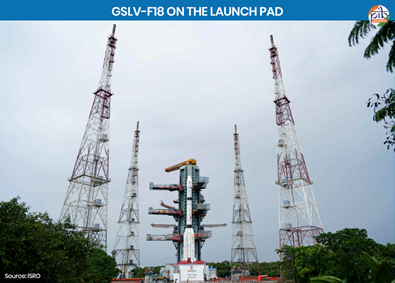
India has taken another significant step toward strengthening its independent navigation capabilities with the successful launch of the NVS-03 navigation satellite aboard the Geosynchronous Satellite Launch Vehicle GSLV-F18.
The Indian Space Research Organisation launched the approximately 2,250-kilogram satellite from the Satish Dhawan Space Centre at Sriharikota on October 30, 2026. The spacecraft was successfully placed into its intended Geosynchronous Transfer Orbit.
Prime Minister Narendra Modi congratulated ISRO scientists and engineers on the achievement, highlighting its importance for India's indigenous satellite navigation system, NavIC.
The mission represents an important technological development because independent navigation infrastructure is closely connected with economic activity, transportation, telecommunications and strategic security.
What Is the NVS-03 Satellite?
NVS-03 is the third satellite in India's next-generation navigation satellite series. It has been developed to strengthen the Indian Regional Navigation Satellite System, commonly known as NavIC.
Navigation satellites transmit precisely timed radio signals that compatible receivers can use to calculate position and time.
The reliability of these services depends on accurate onboard clocks, stable orbital operations, adequate satellite coverage and suitable receiving equipment.
The NVS-03 mission is intended to improve the continuity and capabilities of India's regional navigation infrastructure.
Important Details of the GSLV-F18 Mission
- Mission: GSLV-F18/NVS-03.
- Launch date: October 30, 2026.
- Launch location: Satish Dhawan Space Centre, Sriharikota, Andhra Pradesh.
- Organisation: Indian Space Research Organisation.
- Launch vehicle: Geosynchronous Satellite Launch Vehicle.
- Satellite: NVS-03.
- Satellite mass: Approximately 2,250 kilograms.
- Initial target orbit: Geosynchronous Transfer Orbit.
- Satellite navigation system: NavIC.
- ISRO Chairman: V. Narayanan.
- Mission significance: Strengthening India's independent positioning, navigation and timing capabilities.
What Is NavIC?
NavIC stands for Navigation with Indian Constellation. It is India's indigenous regional satellite navigation system, developed by ISRO.
The system was originally known as the Indian Regional Navigation Satellite System, or IRNSS.
NavIC is designed to provide positioning, navigation and timing services across India and a region extending approximately 1,500 kilometres beyond the country's boundaries.
Unlike global navigation systems designed for worldwide coverage, NavIC is primarily focused on India and its surrounding region.
The development of NavIC is strategically important because navigation infrastructure supports many essential activities.
How Satellite Navigation Works
A satellite navigation receiver estimates its location by analysing signals transmitted by navigation satellites.
Each satellite broadcasts information concerning its orbital position and the precise time associated with the signal.
Because radio signals travel at the speed of light, the time taken for a signal to reach a receiver provides information about the distance between the satellite and receiver.
By combining measurements from multiple satellites, a receiver can estimate its position and correct for timing differences.
This process is generally called satellite-based ranging or trilateration.
Accurate positioning depends on several factors, including satellite geometry, clock accuracy, atmospheric conditions, signal quality and receiver design.
Why Are Atomic Clocks Important?
One of the most important technological features of NVS-03 is its use of atomic-clock technology.
Atomic clocks provide extremely stable time measurements by using the characteristic frequencies associated with atomic transitions.
In satellite navigation, even very small timing errors can produce significant positioning errors because radio signals travel approximately 300,000 kilometres per second.
For example, a timing error of one microsecond corresponds to approximately 300 metres of signal travel.
Consequently, precise timing is fundamental to reliable satellite navigation.
According to the reported mission details, NVS-03 carries an indigenous atomic clock alongside procured atomic clocks.
This reflects India's efforts to strengthen domestic capabilities in precision timing technologies.
What Are the L1, L5 and S-Band Signals?
Navigation satellites transmit radio signals within designated frequency bands.
The NVS-03 satellite incorporates an L1 navigation signal in addition to the existing L5 and S-band navigation signals associated with NavIC.
L1 Band
The L1 band is widely used in satellite navigation. Its inclusion can improve compatibility with suitable navigation receivers and support broader adoption of NavIC services.
L5 Band
The L5 band is another important satellite navigation frequency range used for positioning applications.
S Band
NavIC's S-band navigation capability is a distinctive element of India's regional system.
Multiple signal bands can support improved receiver design and help address certain sources of navigation error, depending on the receiver and operating conditions.
Why Does India Need Its Own Navigation System?
Independent navigation infrastructure can strengthen technological sovereignty and reduce reliance on foreign-operated services for critical applications.
Satellite navigation supports economic activities as well as strategically important operations.
Having domestic control over navigation satellites, ground infrastructure and service planning can improve India's ability to maintain and develop regional positioning services according to national requirements.
However, indigenous capability does not necessarily require excluding other navigation systems. Compatible receivers may benefit from using multiple constellations where supported.
Applications of NavIC in Everyday Life
1. Road Transportation
Satellite navigation helps vehicles determine location and supports route guidance, fleet tracking and transportation management.
2. Maritime Navigation
Navigation services can assist vessels with positioning and route planning. Reliable location information is particularly important for coastal and offshore operations.
3. Disaster Management
Accurate positioning can support emergency response, field coordination and the mapping of affected locations.
4. Agriculture
Satellite navigation can support precision agriculture, field mapping and the operation of compatible agricultural machinery.
5. Telecommunications
Precise timing is important for synchronising communication networks and other digital infrastructure.
6. Scientific Research
Satellite positioning and timing technologies support geodesy, surveying, environmental monitoring and other research applications.
7. Strategic Applications
Reliable positioning and timing services can support defence-related logistics, navigation and communication infrastructure, subject to system capabilities and operational requirements.
Understanding Geosynchronous Transfer Orbit
The NVS-03 satellite was placed into a Geosynchronous Transfer Orbit, commonly abbreviated as GTO.
A transfer orbit is an intermediate orbit used to move a satellite toward its intended operational orbit.
In a typical geosynchronous transfer mission, a launch vehicle places the spacecraft into an elliptical orbit. Subsequent orbital manoeuvres allow the spacecraft to approach its planned operational configuration.
Successful insertion into GTO is an important launch milestone, but it should not automatically be interpreted as confirmation that every later commissioning activity has been completed.
What Is GSLV?
GSLV stands for Geosynchronous Satellite Launch Vehicle.
It is an Indian launch-vehicle family developed to carry satellites into high-energy transfer orbits.
The GSLV programme is particularly important because launching relatively heavy satellites into such orbits requires substantial propulsion capability.
India's development of indigenous cryogenic propulsion has been a significant part of its launch-vehicle technological progress.
The GSLV-F18 mission was reported as the twentieth flight of the GSLV.
What Is Cryogenic Rocket Technology?
Cryogenic rocket engines use propellants stored at extremely low temperatures.
Liquid hydrogen and liquid oxygen are a commonly used cryogenic propellant combination.
Such engines can achieve high propulsion efficiency, but their development involves demanding engineering challenges.
These include cryogenic fluid storage, turbopumps, combustion stability, thermal management and reliable engine operation.
Mastery of cryogenic propulsion strengthens a country's ability to launch satellites into demanding orbital trajectories.
NavIC Compared with Other Satellite Navigation Systems
Several countries and international organisations operate satellite navigation constellations.
GPS: The Global Positioning System is operated by the United States.
GLONASS: A global satellite navigation system operated by Russia.
Galileo: A global navigation system developed by the European Union.
BeiDou: China's satellite navigation system.
NavIC: India's regional satellite navigation system.
QZSS: Japan's regional satellite navigation system, designed to complement navigation services in its coverage region.
The key distinction is that global systems aim to provide worldwide navigation coverage, while regional systems focus on particular geographic areas.
What Did the ISRO Chairman Say?
According to DD News reporting, ISRO Chairman V. Narayanan said the successful NVS-03 launch restored the NavIC constellation to its minimum operational configuration of four satellites.
He also highlighted the precise injection of the spacecraft into its intended orbit.
The report stated that the interval between successive GSLV missions was 56 days, representing the shortest turnaround achieved for the vehicle at that time.
These developments indicate progress in launch operations and constellation maintenance.
Nevertheless, restoring a minimum configuration should be distinguished from completing the full intended constellation or guaranteeing uninterrupted service for every possible application.
Economic Importance of Satellite Navigation
Satellite navigation infrastructure contributes to the wider digital economy by enabling location-aware services and precision timing.
Potential economic applications include transportation, logistics, mapping, telecommunications, agriculture and surveying.
Indigenous satellite navigation can also encourage domestic research and development in receivers, antennas, integrated circuits, software and positioning applications.
However, wider commercial adoption depends on the availability of compatible devices, technical standards, service performance and demand from users.
Challenges Facing India's Navigation Programme
Maintaining a reliable satellite navigation system requires continuous investment and technical expertise.
Important challenges include maintaining satellite health, replacing ageing spacecraft, developing dependable atomic clocks and ensuring reliable ground-control operations.
Signal interference, jamming and spoofing are also concerns for satellite navigation systems around the world.
Another important challenge is encouraging compatible receiver technology and integrating regional navigation services into widely used consumer and industrial devices.
These challenges explain why the development of a navigation constellation involves more than launching satellites.
Why NVS-03 Matters for Aatmanirbhar Bharat
Aatmanirbhar Bharat emphasises strengthening domestic technological and industrial capabilities.
Navigation satellites require expertise in spacecraft design, propulsion, precision timing, communication systems, electronics, software and ground infrastructure.
Developing these capabilities within India can improve technological resilience and create opportunities for research institutions and domestic manufacturers.
The NVS-03 mission is therefore relevant not only to space exploration but also to industrial development and strategic infrastructure.
Important Facts for UPSC, SSC, Railway and Banking Examinations
- Satellite: NVS-03.
- Launch vehicle: GSLV-F18.
- Launch date: October 30, 2026.
- Launch centre: Satish Dhawan Space Centre.
- Location: Sriharikota, Andhra Pradesh.
- Organisation: ISRO.
- ISRO Chairman: V. Narayanan.
- Satellite mass: Approximately 2,250 kg.
- Target injection orbit: Geosynchronous Transfer Orbit.
- Navigation system: NavIC.
- NavIC full form: Navigation with Indian Constellation.
- IRNSS full form: Indian Regional Navigation Satellite System.
- Coverage design: India and approximately 1,500 km beyond its boundaries.
- Navigation signals: L1, L5 and S band.
- Important technology: Atomic clocks.
- GSLV mission number: Twentieth flight.
UPSC Mains Practice Question
Question: Examine the strategic and economic importance of India's indigenous satellite navigation system NavIC. How do next-generation navigation satellites contribute to technological self-reliance?
Suggested answer: Begin by explaining satellite navigation and the development of NavIC. Discuss its applications in transportation, telecommunications, agriculture, disaster management and strategic infrastructure. Explain the significance of indigenous atomic clocks, regional coverage and next-generation signals. Examine challenges involving constellation maintenance, receiver compatibility, signal security and technological development. Conclude by highlighting the importance of sustained investment in reliable navigation infrastructure.
Frequently Asked Questions
What is NVS-03?
NVS-03 is the third satellite in India's next-generation navigation satellite series, developed to strengthen NavIC.
When was NVS-03 launched?
ISRO launched NVS-03 on October 30, 2026.
Which rocket launched NVS-03?
The satellite was launched aboard GSLV-F18.
What is the full form of NavIC?
NavIC stands for Navigation with Indian Constellation.
What is the difference between NavIC and GPS?
GPS is a global satellite navigation system operated by the United States, whereas NavIC is an Indian regional navigation system designed primarily for India and surrounding areas.
Why are atomic clocks used in navigation satellites?
Atomic clocks provide precise timing information needed to calculate distances from satellite signals and determine receiver position.
Does NVS-03 make NavIC available on every smartphone?
No. Smartphone support depends on compatible hardware, software, available signals and the operational readiness of the navigation service.
Conclusion
The successful launch of NVS-03 marks another important development in India's space programme and its efforts to strengthen indigenous navigation infrastructure.
The mission combines advanced satellite engineering, precision timing technology and launch-vehicle capabilities.
Its long-term significance will depend on successful satellite commissioning, continued constellation maintenance and wider adoption of compatible navigation technology.
For competitive examination aspirants, NVS-03 provides an important current-affairs example connecting space science, physics, strategic technology and India's vision of technological self-reliance.
Sources and Further Reading
This article is an original educational analysis by the Vitorr Classes Editorial Team, based on DD News reporting and established scientific principles of satellite navigation.
Read Original DD News Report →
Explore ISRO Navigation Services →
Editorial disclaimer: Vitorr Classes is an independent educational platform and is not affiliated with ISRO or DD News. Mission developments should be interpreted according to official updates, and general technical explanations should not be confused with confirmed specifications of individual spacecraft.
 History Geography General Science Economy
 Oxford Student Atlas India Competitive